
Summary
-
Any policy or decision, whether local and stand-alone or global and integrated, that aims to ensure a sustainable consumption of fossil and other organic fuels, needs to consider appropriately issues of air pollution, in particular the emission of NOx and particulate matter. A fundamental prerequisite to effective policymaking is the availability of an observing system that gives access to quantification and mapping of the current air quality and of the impact of past and future regulations.
Air quality monitoring has hitherto been relying mostly on measurement networks of in-situ atmospheric composition, complemented with chemical transport modelling (CTM) to fill in the gaps between measurements. The advent of hyperspectral satellite sounders at high-resolution (typically 5 x 5 km² on ground) has enabled global mapping of atmospheric pollutants at regional and even nearly local scales, however, only once per day and in cloud free weather, without access to the diurnal cycle of pollutants and of their emissions. In the next step the international community has elaborated a strategy for integrated observation of air quality with a constellation of these satellites: the CEOS LEO+GEO AQ Constellation, gathering Low Earth Orbit instruments (LEO) with global mapping once per day, and Geostationary instruments (GEO) limited to a geographical area like Europe or North America but also with hourly sampling and thus access to the diurnal cycle. The European programme Copernicus contributes to this LEO+GEO AQ constellation with the Sentinel-5 Percorsor (S5P) satellite since 2017 and the launch of several Sentinel-4 (GEO) and Sentinel-5 (LEO) after 2023.
To make these new data sets truly fit-for-purpose in the context of air quality policy making, several challenges need to be addressed, among others:
- Improve even further the horizontal resolution to map and monitor pollution on the scale of local policies (e.g. the Low Emission Zones established in several large Belgian cities),
- Determine the non-trivial relation between the (tropospheric) pollutant column measured by satellite instruments and the surface concentration measured by in-situ networks,
- Evaluate to what extent differences in measurement geometry and sensitivity between LEO and GEO observations lead to a different perception of atmospheric details (e.g., through spatial blurring and obscuration effects), hence, to an internal incoherence of the satellite constellation.
The project aims to explore these three topics, with applications specific to Belgium, its regions and cities, by bringing together the expertise in satellite-based monitoring of tropospheric composition at BIRA-IASB with the in-situ and modelling expertise and the relation with key stakeholders makers at IRCEL-CELINE. For challenges (1) and (2), a mostly observational approach is adopted which is meant to be complementary to the CTM method adopted in the Copernicus Atmosphere Monitoring Service (CAMS). More specifically, the work plan targets advances:
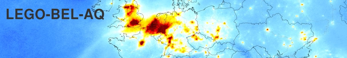
- On the first challenge by developing oversampling tools for satellite data, based on selective aggregation (trading temporal for horizontal resolution) and geostatistical interpolation techniques (WP1 of the project), and by applying these on S5P observations of tropospheric NO2 over Belgium, with a focus on key cities such as Brussels, Antwerp, Ghent, and Liège (WP2). The results, both the high-resolution maps and the analyses of the temporal evolution (with reference to the policy in effect), will be made available online.
- On the second challenge by comparing the high-resolution S5P maps over Belgium with the in-situ measurements and derived gridded products (e.g. the RIO data set) to assess under which conditions the high-resolution satellite maps of the NO2 column can be considered as representative for the distribution of the NO2 surface concentration (also in WP2);
- On the third challenge by extending the OSSSMOSE observing systems metrology simulator at BIRA-IASB with dedicated 3D GEO observation operators and applying these on representative atmospheric model fields, digital elevation models and orbital parameters of S5P, Sentinel-4 and Sentinel-5, in order to quantify the significance of these effects on the internal coherence of the CEOS LEO+GEO AQ Constellation (WP3).
To ensure uptake by key stakeholders, a separate work package (WP4) is dedicated to user interaction: collecting requirements, ensuring availability of outcomes, and designing a roadmap for the future to take this work to an operational level.
Work packages
-
WP1 – DEVELOPMENT OF A SPATIO-TEMPORAL MAPPING AND DOWNSCALING TOOLBOX FOR SATELLITE ATMOSPHERIC COMPOSITION DATA SETS
This work package deals with the necessary software development to create contiguous, regularly gridded maps of atmospheric composition parameters (such as the tropospheric NO2 column) at a resolution close to or better than the satellite pixel size (Sentinel-5p: 3.5x5.5km2). As baseline (Task 1.1), it will be based on data aggregation over multiple orbits, taking advantage of the orbit cycle of 16 days, meaning that within a time period of 16 days, subsequent orbits do not exactly coincide (see e.g. Sun et al., AMT v12, 2018 and references therein). Moreover, temporal aggregation will be performed following several meaningful selection criteria, such as week day vs. week-end, wind direction (from ERA-5 meteorological fields), etc. Particular attention will be paid to uncertainty propagation and quantification. In a second step (Task 1.2), the potential of interpolation to a finer grid will be investigated, making use of geostatistical techniques such as Variograms and Kriging to properly account for spatial correlations in the data. The set of software tools resulting from these tasks will be properly documented (user manual) and finally (Task 1.3), an assessment report will be created, evaluating the strengths and weaknesses of the tools, such as maximum achievable true resolution (i.e. the response to a theoretical point source) and a gap analysis on the uncertainty characterization.WP2 – APPLICATION OF THE WP1 TOOLBOX ON SENTINEL 5P NO2 DATA OVER BELGIUM AND COMPARISON TO IN –SITU NETWORK DATA
This work package deals with the application of the tools developed in WP1 on Sentinel-5 precursor data over Belgium. In Task 2.1, several horizontal gridding scales and various temporal selection criteria will be explored, both to maximize the achieved horizontal resolution and to uncover spatio-temporal patterns in the tropospheric NO2 columns, as can be expected from variations in economic activity, heating, wind direction, etc. A catalogue of such maps will be compiled for Belgium, the regions, and several major cities. A limitation of satellite data of NO2 is that they do not directly probe pollutant concentrations in the boundary layer/near the surface. To assess the correlation between tropospheric NO2 columns and BL concentrations over Belgium, the high-resolution S5p-based maps will be compared to in-situ network and high spatial resolution emission data, and to contiguous maps of surface concentrations derived from these in-situ measurements by interpolation and CTM assimilation. Special care will be given to reduce as much as possible sampling differences, e.g. by applying the same temporal aggregation and, if applicable, horizontal gridding. This work constitutes Tasks 2.2 and 2.3. In Task 2.4, which is to start 2 years into the project, the multi-annual temporal evolution of the mapped satellite NO2 field will be investigated, not only for expected seasonal effects, but also for the effects of changes in regulations if/when they occur (such as those foreseen in the LEZ regulations for Antwerp and Brussels).WP3 – PREPARING FOR THE GEOSTATIONARY SOUNDERS: AN OBLIQUE VIEWING GEOMETRY
This aim of this work package is to quantify the impact of the oblique viewing geometry of Sentinel-4 (and the other components of the geostationary constellation, i.e. TEMPO and GEMS) on the spatio-temporal coverage and resolution of measurements of tropospheric pollution. More specifically, while the pixel footprint of these instruments may be of a size similar to that of the latest nadir LEO sounders, the oblique measurement geometry introduces some (implicit) effects on the resolution and coverage, with any diurnal signature further affected by observing under varying solar angles throughout the day. This includes for instance the effect of a long and offset slant stratospheric column of NO2 on the derived tropospheric columns, and the shadowing due to orographic features and due to clouds. As a first step, a comprehensive assessment of such challenges for the high-resolution observation of tropospheric pollution from the upcoming geostationary sounder will be made (Task 3.1). To quantify a selection of these effects, we will construct 3D GEO observation operators and integrate them in the OSSSMOSE (Observing System of Systems Simulator for Multi-missiOn Synergies Exploration) environment (Task 3.2), as was already done for LEO sounders in previous projects (EC FP6 GeoMON, EC H2020 GAIA-CLIM, PRODEX ACROSAT). These observation operators are then applied on modelled atmospheric fields (CAMS-regional, IMAGES) to quantify the significance of these effects for measurements of tropospheric pollution, in terms of resolution (Task 3.3) and coverage (Task 3.4). Finally, in Task 3.5, the results of these simulations are assessed in the context of a future use of WP1 tools on geostationary (i.e. Sentinel-4) observations of NO2 pollution in/above Belgium.WP4 – OUTREACH AND VALORISATION
The scientific tools developed in this project can only support integrated policies on the sustainable use of natural resources if they are made available to all key stakeholders in a format that is fit-for-purpose. To that end, this work package aims at consulting a set of identified stakeholders early on in the project, both on needed developments and on preferred format for communication of results (Task 5.1). In view of the bi-focal nature of the project, i.e. (1) development and applications for the current LEO sounder S5p, and (2) preparatory developments for the upcoming GEO sounders, this user consultation will work along 2 separate axes: the actors involved in monitoring local air pollution on the one hand (DG Environment, EEA, BELSPO, VMM, Environment Brussels,…), and on the other the teams preparing the retrieval and use of atmospheric composition data from Sentinel-4 (the space agencies, CAMS). The baseline method for dissemination of results and technical material will be an online platform hosting both the report-like material and the data sets (Task 5.2), and the publication of results in peer-reviewed scientific journals. Finally, to prepare for a potential service-oriented application of the developments from this project, a requirements analysis will be performed, from which a rudimentary roadmap can be suggested (Task 5.3). Deliverables
-
Number & version Title Document link Deliverable D2.1.1 (v1.1, March 2021) Catalogue of high-resolution NO2 maps, 1st version Deliverable_D2.1.1_v1.1.pdf
Project description
- You are here:
-
Home

- Project description